


32km

mikaelerouzic
Gebruiker

Lengte
30 km

Max. hoogte
134 m

Positief hoogteverschil
394 m
Km-Effort
35 km

Min. hoogte
57 m

Negatief hoogteverschil
394 m
Boucle
Ja
Datum van aanmaak :
2014-12-10 00:00:00.0
Laatste wijziging :
2014-12-10 00:00:00.0
--
Moeilijkheid : Medium

Gratisgps-wandelapplicatie
 SityTrail
IGN / Geografische instituten
SityTrail Plus
De wereld gaat voor u open
Over ons
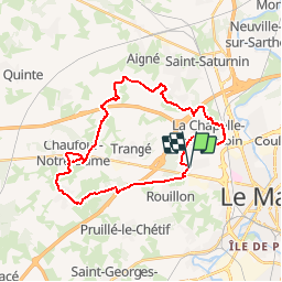
Tocht Lopen van 30 km beschikbaar op Pays de la Loire, Sarthe, Le Mans. Deze tocht wordt voorgesteld door mikaelerouzic.
Beschrijving
32km
Plaatsbepaling
Land:
France
Regio :
Pays de la Loire
Departement/Provincie :
Sarthe
Gemeente :
Le Mans
Locatie:
Unknown
Vertrek:(Dec)
Vertrek:(UTM)
287352 ; 5322407 (31U) N.
Opmerkingen